Il Tuo Carrello della spesa è Vuoto!
Tel. 0932.86.50.32
Fax. 0932.80.21.75
Carrello della Spesa
0 prodotto(i) - 0,00€ACCESSORI NAUTICI
MANUTENZIONE
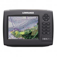
HDS-7m Gen2

Chartplotter
Il display da 6.4"/16,3 cm con retroilluminazione a LED offre una divisione in due pannelli facile da visualizzare - ad esempio, con mappa, radar o dati motore e sistema - tutto ad un prezzo più che conveniente. Inoltre, HDS-7 offre l'opzione aggiunta di una visualizzazione a tre finestre.
Caratteristiche Principali
- Massima rapidità
- In tempo reale StructureMap™ predisposizione
- Antenna GPS interna estremamente precisa
- Opzioni di rete NMEA 2000® e Ethernet ad alta velocità
- Display ad alta luminosità visibile in pieno sole con retroilluminazione a LED.
- Servizio Advantage 5 Years
Specifiche
| Panoramica | |
| Display | 6.4 in \ 163 mm 16-bit color Full VGA SolarMAX™ PLUS TFT |
| Resolution | Full VGA 480V x 640H |
| Communication | NMEA 2000®, 0183 and Ethernet |
| Languages | 23 |
| Media Port | One (1) SD/MMC slot |
| Warranty |
Two year |
| Display | |
| Display Resolution | 480 x 640 (H x W) |
| Display Type | 16-bit color Full VGA SolarMAX™ PLUS TFT |
| Display: Retroilluminazione | Screen/Keypad |
| Tipo Retroilluminazione | Pure white LED |
| Display Multi Lingua | Yes |
| GPS and Sonar Overlay Data | Yes |
| Presentazione Schermo Diviso | Yes |
| Display Size | 6.4 in \ 163 mm |
| Connettori di Rete | |
| Interfaccia NMEA 0183 | up to 38,400 baud |
| Connettori | NMEA 2000®, NMEA 0183 and Ethernet |
| Uscita NMEA | 0183/2000 |
| Tecniche/Ambientali | |
| Temperatura Funzionamento | -15°C to 55°C (5°F to 130°F) |
| Memoria Interna di Back-up | Yes |
| Custodia |
Sealed and waterproof |
| Product Width | 8.8 in \ 224 mm |
| Product Depth | 3.5 in \ 88 mm |
| Product Height | 6.4 in \ 163 mm |
| Alimentazione | |
| Alimentazione (Tensione di Alimentazione) | 10 - 18 vDC |
| Numero equivalenza Carico NMEA 2000 | 1 network load (50mA) |
| Comunicazioni | |
| Ingresso NMEA | Yes |
| Navigazione GPS | |
| Navigazione: Rotte | 200 |
| Navigazione: Salvataggio Waypoint | 5000 |
| Tipo Antenna GPS | Internal, high-sensitivity GPS+WAAS (Americas) or GPS+EGNOS+MSAS (non-Americas) |
| Man Overboard Feature | Yes |
| Plot Trails |
Up to 10 trails - up to 12,000 points/trail |
| Allarmi GPS | Yes |
| Custom Mapping |
Optional Navionics® Platinum+ and Platinum chartcards with TurboView™ for worldwide coverage - as well as Navionics® HotMaps™ Platinum, Lowrance Hot Spots® PRO and LakeMaster® ProMaps* (Americas) * Mapping cards available through LakeMaster Lake Map retail outlets. |
| Background Mapping |
Expanded U.S. BaseMap or Insight USA™ (Americas) or Worldwide background map (non-Americas) |
| Altro | |
| Linguaggi | 23 |
| Altre Caratteristiche | Fishfinder features available via Ethernet networking, optional SIRIUS Satellite Weather/Radio and new 2-year limited warranty |
| Capacità Scheda di Memoria |
One SD/MMC memory card slot |
| Radar | |
| Tipo Antenna | Optional Lowrance radar choices available |
Scrivi una recensione
Il Tuo Nome:La Tua Recensione: Nota: Il codice HTML non è tradotto!
Punteggio: Negativo Positivo
Inserisci il codice nel box di seguito:


